Introduction
Throughout
history, rivers more than any other natural phenomenon, have played a decisive
role in the progress of humanity. Godana (1985) noted that it was on their
banks that early great civilizations sprang [1].
Throughout history, rivers more than any other natural phenomenon, have played
a decisive role in the progress of humanity. Rivers, the most important source
of fresh water available for the impoverished nations of the arid and semi-arid
areas of Africa, are increasingly coming under stress. Many of them are shared
with other nations. The abundance of international shared river basins in
Africa (CNRET, 1978; Wolf et al., 1999), with its greatest percentage of area
covered by international basins (62%), presents special difficulties. It can
be attributed to the colonial administrations, which arbitrarily drew the
political boundaries between the countries in the second half of 19th century.
As a result, no river basin is fully contained within the borders of a single
nation in the Horn of African region, where the Jubba and Shabelle river basins
are located, which is the subject of this paper.
Rivers carry water – a basic human necessity [2] which is a critical resource for all aspects of human existence, environmental survival, economic development and good quality of life. Freshwater is one of the most essential of the elements that support human life and economic growth and development as the UN (1998) identified lack of freshwater as being one of the five major problems facing humanity, while the UNEP (1999) reported water shortage as one of the two most worrying problems for the new millennium. The whole issue of global food security is closely linked to water availability (Falkenmark, 1997). Globally, freshwater constitute only 2.5% of all waters on the Earth and most of easily available freshwater resources exist in rivers and lakes (Shiklomanov, 1997) that are shared by several countries. Globally, as far as the water resources management is concerned, three related world trends strongly increase demand for water and greatly exacerbate the water situation. These are population growth, economic development and climate change.
As in general terms water resources management becomes increasingly critical and as new local and national sources of water become scarce, limited, expensive and difficult to exploit (Delli Priscoli, 1998) many countries in the arid and semi-arid regions that are facing water crisis (Biswas, 1996) will be increasingly forced to consider the possibilities of utilizing the water that is available in international rivers. Thus, the concerns relating to the use of international waters are becoming increasingly more important and complex, as most remaining major easily exploitable sources of freshwater are now in internationally shared rivers (Biswas, 1981; WB, 1998). In terms of land area within international basins, Africa has the greatest percentage of all, 62% and 60 shared watercourses (Wolf et al., 1999).
The lack of integrated management on the basis of common management for most of the continent’s transboundary water bodies could be a potential threat to regional stability. The issue of international shared water resources, which is highly political in its nature (Nakayama, 1997), is currently a subject of considerable debate internationally. Some have stressed the apparent inevitability of serious inter-state conflict over competition for shared water resources while some others believe that it will provide an opportunity and instrument for greater cooperation among countries and reasons to search for common security and peace.
Scope and Methodology
Second half of last century, it was experienced that the concerns relating to the use of international water are becoming increasingly more important and complex. Water is a scarce resource in the Horn of African region where the Jubba and Shabelle River Basins are geographically located, as shown in Figure 1.
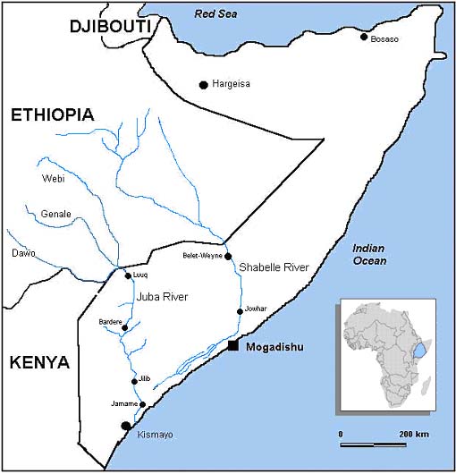
Figure 2. Map showing the Jubba and Shabelle River Basins in Horn of Africa.
The overall purpose of this paper is to examine the physical and developmental aspects of the two rivers, the Jubba and Shabelle in the Horn of Africa. It will analyze the resulting hydropolitics and the looming water conflicts from downstream perspective. The analysis will be based on the interrelated factors shown in Figure 2, which are assumed to have large influence on the common management and development of shared water resources in International River Basins. The paper also presents some aspects of interaction between Somalia and Ethiopia over these common river systems. The paper suggests an alternative solution to prevent future water conflict over these shared resources in the two basins.

Figure 2. Factors influencing Management of International River Water Resources.
As a methodology, literature reviews and document review, information gathered from relevant organizations and sources was carried out. As a background, the paper will first present the issue of international river basins from the point of view of international legal frameworks and institutional mechanisms. Interview with relevant people on the issue of the effectiveness of the international water law has also been carried out. Gathered information are first presented and analyzed in a manner to describe the selected river basins from physical, hydrological and economic as well as development aspects. This will be followed by hydropoöitical analysis of the two river basins.
Literature Review for International River Basins
International Rivers
According to a study carried out by a group of scientist (Wolf et al., 1999), the number of international river basins in the world were identified to be 261, covering 45.3% of the world land area excluding Antarctica. In terms of land area within international basins, Africa has the greatest percentage of all, 62%. Five of the world’s eight rivers that pass through eight or more countries are in Africa (ibid.).
International
Legal Perspectives on International River Basins
The Application of Different Theories in International Water Law
The various uses to which the shared waters of international river basins are put create problems of both technical and juridical nature (Godana, 1985). Traditionally, international water law recognizes five main theories (Utton and Teclaff, 1978) that attempt to define and delineate the rights of basin states to use water from a shared river system. These are:
The theory of absolute territorial sovereignty. According to this theory, a state, as ‘master of its territory’, may adopt in regard to watercourse within its national territory all measures deemed suitable to its national interest, irrespective of their effects beyond its borders (Menon, 1975). In other words, a state can do as it pleases and is entitled to do as it chooses with its waters within boundaries ignoring the effects of its actions on neighboring states. Obviously, this theory is favorable to upper basin state. Downstream states have always opposed the absolute territorial sovereignty doctrine, which is never implemented in any water treaty.
The theory of absolute territorial integrity. This theory, which is also known as the theory of natural flow of river, is the direct opposite of that of absolute territorial sovereignty. It espouses the old common law doctrine of water rights whereby a lower riparian (basin state) claims the right to the continued, uninterrupted (or natural) flow and unaltered condition of the water from the territory of the upper riparian state (Godana, 1985). According to this theory, a riparian state may not proceed with the harnessing of a section of an international waterway traversing its territory if it is of a nature to cause injury to the interests of other basin States. This theory is thus favourable to the lower-basin state(s) and awards ‘a veritable right of veto to downstream states’ (ibid).
The theory limited territorial sovereignty and of limited territorial integrity. These theories are in practice complementary and even identical. Therefore they can be considered together. They consist in the assertion that every state is free to use the waters flowing on its territory, on condition that such utilization in no way prejudices the territory or interests of other states. Permiting use of rivers as far as no harm is done to other riparian States; these theories are where the concept of reasonable use originated. In an attempt to advance and improve on the doctrine of limited territorial sovereignty and integrity, this theory insists on a ‘community approach’. This approach suggests that all basin states have a common interest in developing the basin (ibid.). Under this theory, state boundaries should be ignored and drainage basin is regarded as an economic and geographic unit. This doctrine represents a more balanced approach that seeks to contribute to the joint development of riparian states within a shared basin through equitable division and sharing of benefits.
Each of these theories
reflect different historical and judicial approaches to solving the problems
experienced by riparian States (ILA, 1966; ILC, 1994) and also reflect an
important change from rights to ownership of water, to one which strives to
ensure that the interests of all parties are met equitably and effeciently.
As international law as an instrument of regulations on the transboundary
freshwater issues is at present inconclusive and weak (Naff, 1993). Management
of international river basins might be possible only if the affected and concerned
countries accept the limitation to their sovereignty over the common water
resources. It requires mutual agreement to define this limitation. This is,
of course, the obstacle, which can hinder the development of a partnership
between the riparian states.
Law is an instrument that can be used to smooth out conflicts of interest
generated, for instance, in the sharing of water resources. However, the utilization
and management of shared river is subject not only to man-made laws but also
the natural laws, which does not recognize the political and geographical
boundaries. In order to form a framework for cooperation, States sharing water
need first to settle their inter-State dispute over the water in question
on a legal basis. The absence of formal political agreements contributes to
this problem. On the other hand, since each river basin is unique, with its
own economic, geographical, ecological and political variables, no comprehensive
system of rigid rules can anticipate adequately the variations from one basin
to another.
Settlements of Disputes and Conflict Resolutions
When countries disagree over the way in which water resources of an international river basin should be utilized, they have to resort to some disputes settlement procedures. So, before parties or countries sharing water system go into a conflict, which may from water security problem lead to a national security problem (Carlson, 1999), there are three main procedures and methods used to find a solution to the problem. These are (1) negotiation and consultation; (2) mediation and conciliation; and (3) arbitration and adjudication. Dispute over shared water bodies can normally arise at least under two different circumstances, one can be riparian states that have never entered a treaty or agreement, while the other can be an existing agreement which can not provide a binding decision to problem in dispute.
UN Convention
on the Law of Non-navigational
Uses of International Watercourses
A move to reconcile conflicting theories favoring either upstream or downstream countries and resolve the alarming crisis in shared freshwater resources; the UN General Assembly adopted the UN Convention on the Law of Non-navigational Uses of International Watercourses in 1997. This Convention, which is not yet formally ratified and thus not operational, encourages cooperation in order to address equitable, reasonable and non-harmful utilization of the international freshwaters. Many argue that this new legal instrument is too weak to meditate disputing basin states over shared water resources, such as those in the Horn of Africa sharing the Jubba and Shabelle rivers where dispute has been experienced in the past and further dispute potentially exist.
The UN Convention is however an international framework instrument, which may apply in the absence of agreement over shared freshwaters. Cooperation through joint mechanism in the form of commission is a vital necessity if the aims are to achieve equitable, reasonable and non-harmful utilization of the international watercourse. This is what the UN Convention encourages. The backbone of the UN Convention is formed by the two principles: the principles of equitable and reasonable utilisation, and the principle obligation not to cause significant harm. The No-Harm rule is forming a fundamental rule, while the principle of equitable and reasonable utilization is regarded as the cornerstone of international water law. The No-Harm rule seems to favor the lower riparian States, which would heavily advantage from the obligation posed on the upstream States not to cause a significant harm. This would automatically disadvantage the upper riparian States, as any use that causes harm would be deemed inequitable. Gleick (1998) argues also that the inherent conflict between the equitable uses and the obligation not to cause harm is among the weaknesses of the UN Convention.
Rights
and responsibilities for up-and downstrean riparians
in
an international river system in terms of UN Convention.
In
terms of the UN Convention |
Riparian Position
in the River Basin |
| Rights | Equitable & Reasonable Utilization. | Not to be harmed. |
| Responsibilities | Cause No-harm | Allow equitable and reasonable Utilization. |
The above table illustrates the controversy between the two most important articles of the UN Convention based on (i) the principle of equitable and reasonable utilization, and (ii) the obligation no to cause significant harm. As shown in the table, each state in any given river basin – whether upper or lower riparian – has both rights and responsibilities in terms of the UN Convention. The upstream riparian has the rights to equitable and reasonable use of the shared waters, while the downstream riparian have the responsibility to allow the common waters to be equitably shared. On the other hand, upstream riparian States are responsible for and obliged not to cause significant harm, while the downstream riparian States have the rights not to be significantly harmed. As it is unlikely that both can be achieved at the same time without problems, this proofs to be a real dilemma in water sharing rules and allocation. However, it is obvious to note that any expanded or additional activities of water resources developments seem to be harmful to lower States, particularly in the arid and semi-arid regions, where water is naturally and increasingly becoming scarce. So, although the idea that ‘rights’ should accompanied by ‘obligation’ gained acceptance, the UN Convention does not define any principles as being more superior and important than the other in the case of dispute over the utilization of the international watercourses. This analysis is easily applicable to the Juba and Shabelle river basins in the Horn of Africa.
Since the international
water law that could solve the problem in legal terms still remains vague
and uncertain, and many concepts and principles remain also unsettled (Caflisch,
1998), the allocation of the water resources in international shared river
basins is increasingly becoming a major global challenge. The definition of
the concepts, which are intentionally vague, guarantee continued ambiguity
in the principles of customary law (Wolf, 1999). And there is some doubts
raised over the viability of the UN Convention (Caflisch, 1998). The principle
of "reasonable and equitable utilisation" embodied in Article 5
of the UN Convention is somewhat vaguely worded, provides little guidance
in this regard and is prone to subjective interpretations (van der Zaag et
al., 2000). Another author (Gleick, 1998) argues that the principles set forth
in the UN Convention are not binding and offer little concrete guidance to
the problem of allocation of water resources in international river basins.
It is therefore doubtful whether the UN Convention will ever become truly
operational (Caflisch, 1998). It therefore seems impossible to form an institutional
framework or arrangement that could serve the purpose of implementing the
UN Convention because it is wide and vague. Many countries’ governments
are finding the Convention either too strong (upstream) or too weak (downstream).
Utilization of shared water resources should not be only equitable but also
sustainable. So, one must combine and harmonize the two concepts “Equitable
Use and Sustainable Development”.[3]
There is no formally ratified rule of international water law. UN Convention
is not yet operational, because the required number of countries did not yet
ratify it. The UN Convention was open for signature until 21 May 2000 and
requires ratification by 35 States to enter into force and effect. Only sixteen
countries have signed the UN Convention and about half of them ratified it
(Salman, 2001). The reluctance of the Member States to sign and ratify the
Convention could be linked to the “no significant harm” component
– and its relation to the equitable and reasonable utilization component.
It may also be linked to what would be the impact of the UN Convention on
existing as well as future international watercourse agreements. The most
important concern of the UN Convention in its future is therefore the ratification
by the UN member States.
It is therefore safe to say hat this new legal instrument is too weak to meditate disputing basin states over shared water resources, such as those in the Horn of Africa sharing the Juba and Shabelle river systems where dispute has been experienced in the past and further dispute potentially exist.
An
Old Story about Claim for Water Right. Prophet
Ibrahim (or Abraham) lived about 2 000 years B.C. in Mesopotamia.
According to the Holy Quran and narrations by Prophet Mohamed (Peace
be upon him), Prophet Ibrahim left his family (his wife, Hajar and
his baby son, Prophet Ismail) in the desert of Makkah, (now a holy
city in Saudi Arabia), where there was no one to keep them company,
nor was there any water, for he was ordered to do so. He made them
sit over there and placed near them a leather bag containing some
dates, and small water-skin containing some water. Hajar went on nursing
(suckling) Ismail and drinking from the little water she had until
it was all used up. She became very thirsty and the child was crying.
She left him on the al-Marwa hill and hurried to the nearest hill,
as-Safa. She stood there and started looking at the valley keenly
so that she might see somebody, but she could not see anybody. Going
back and forward between the two hills, Haraj became exhausted and
sat next to the baby. Then she heard a voice and saw an angel, Angel
Jibreel, digging the earth until water flowed! She built a little
basin around it. She scooped water with her hands, drank, filled her
water-skin, and nursed her baby. The place from which water flowed
was Zamzam. Muslims till this day drink from the holy water of Zamzam,
and during Hajj they walk between as-Safa and al-Marwa hills to commemorate
this event. |
Physical Aspects of the Shabelle and Juba Rivers
The Shabelle and Jubba River Basins are international river basins in the Horn of Africa occupied by Ethiopia, Kenya and Somalia. In contrary to previous estimations (NWC, 1989), the total drainage area of the two basins, which is geograpgically considered as one basin unit, was recently estimated to 805 100 km2 (Wolf et al., 1999).[4] The two rivers originate from the Bale mountain ranges at an altitude of about 4 000 m in the Ethiopian highlands flowing towards the Indian Ocean crossing the border between Somalia and Ethiopia.
The Shabelle River Basin
The Shabelle river basin in the Horn of Africa is a transboundary river basin shared between Ethiopia and Somalia. Running a distance of about 1500 km, the Shabelle River (meaning Leopard/Tiger) rises in the Ethiopian Highlands and passes through an arid land in eastern region of Ethiopia [5] known as Ogaden Plateau cutting then wide valleys in southern Somalia. After crossing into Somalia, it approaches the coast near Mogadishu. Annual rainfall at the source exceeds 1000 mm. The river does not normally enter the Indian Ocean, but disappears into a depression area, where it is finally lost in the sand in southern Somalia near the town of Jilib, not far from the Jubba river. Only with exceptionally heavy rains in Ethiopia does the Shabelle River break through to join the Jubba and thus succeed in reaching the ocean.
With an average
annual rainfall of 455 mm and much higher potential evaporation, mean annual
runoff of the Shabelle River at the Somali town of Beledweyne is 2 384 million
m3 (FAO, 1989). According to the reports from Ethiopia, annual river runoff
is 3 160 million m3. Over 90% of the runoff is however generated by catchments
within Ethiopia (ibid.). As the river crosses the existing international border
between Ethiopia and Somalia, the Somali City of Beledweyne in the Hiiraan
region is the most important point where the river flow and its water quality
could be observed inside Somalia. The river has a high saline content even
during high flows. The river basin has recurrent droughts and devastating
floods generated by heavy rains in the Ethiopian highlands which often cause
flooding in Somalia with huge damages. In 2006, the river has been affected
by the worst flooding in many years and many provinces were badly affected
by the floods.


The Shabelle and the Jubba River Basin in the Horn of Africa.
The Jubba River Basin
Like the Shabelle, the Jubba River originates from the Ethiopian Highlands, where three large tributaries, the Genale, the Dawa and the Weyib, meet near the border with Somalia to form what is known in Somalia the Jubba River. The rainfall at the source reaches 1500 mm/y, dramatically decreasing southwards and the mean is 550 mm. The basin falls mainly in the arid and semi-arid zone and is generally drought prone with erratic rainfall. In Somali, the Jubba basin region receives most rains in Somalia and the river gives its name to two Somali administrative regions. The Somali town of Luuq is the most important point to observe the runoff of the Jubba River as it crosses the border. The Jubba, which enters the Indian Ocean at the portcity of Kismayo, has a total length of 1 100 km, 550 km of which is in Somalia. The mean annual runoff at the town of Luuq is 6 400 million m3; Ethiopia again contributes over 90% (FAO, 1989). Kenya occupies larger part of the basin and section of the Dawa river forms part of the border with Ethiopia, but as there are no known tributaries originating there contributing to the main river channel with significant flow of surface runoff; it does not normally contribute to the Jubba, and has no access to the main river thus any significant interests for the water resources in the river.
The Jubba basin
region is primarily savanna and is the richest part of Somalia due to its
fertility as well as biodiversity. The Jubba has flood seasons in both spring
and autumn. The river expeinced 1997 its worst flood in living history. The
Jubba valley is part of the nation's chief agricultural region, and the river
is extensively used for irrigation.
The Shabelle and Jubba rivers are the only rivers in Somalia, while they are
the second and third largest of the twelve rivers of Ethiopia. The Shabelle
is larger in size and longer in distance than the Juba, but these did not
lead the Shabelle to be larger in terms of runoff due to climatic and geological
conditions. The two rivers are now international and it is historically attributed
to the Colonial Administration, who arbitrarily drew the political borders
between Somalia and Ethiopia during late 19th and mid 20th centuries (Drysdale,
1964). The impact of colonial division on Somalia’s water resources
is significant, but will be understood more in the future. As Somalia's most
water resources exist in these rivers, runoff contributions by catchments
in Somalia are normally minimal. The effects of this factor will be analysed
later in the paper.
Developmental Aspects of the Shabelle & Juba Rivers
Water Resources Development in Ethiopia
In upstream areas of Ethiopia, there are few developments based on the two rivers' water resources. In 1988, Ethiopia completed with the help of Soviet engineers the Melka Wakana hydroelectric project on the upper reaches of the Shabelle with installed capacity of 150 MW (Markakis, 1998). With a storage capacity of 760 million m3 and water body covering 80 km2, the dam which is Ethioipia’s largest hydroelectric generator was also intended for irrigation in the downstream areas as well as flood mitigation. Ethiopia has carried out a master plan study in the Shabelle river basin. As an outcome from the master plan, Ethiopia has constructed a major dam on the Shabelle in 2001 near Godey for irrigation development. Due to the very narrow arable alluvial plains, there are few permanent agricultural settlements along the Shabelle River in the Somali National Region of Ethiopia. Majority of these people living in the region are traditionally nomads in semi-desert environment.
Ethiopia is now carrying our a master plan study on the Genale-Dawa rivers sub-basin which is part of all the river basins of the country on the basis of which the sub-basin development plan will be formulated. The specific objectives of the Genale-Dawa River Basin Integrated Resources Development Master Plan Study are to study the most attractive water resources projects in the sub-basin and prepare for three water projects for future financing. The African Development Bank financed the project. These water projects, when undertaken, will have significant impacts on the downstream uses.
Water Resources Development in Somalia
As the two rivers supply the Somalia's rice bowl and support important economic areas in southern Somalia, several agricultural development projects have been implemented based on the water resources of the two rivers. As the Jubba river is exetnetively used for irrigation, projects that were implemented or planned on the Juba River include: Juba Sugar Project (JSP), often known as Mareerey, irrigating sugarcane near Jilib; Mugaambo Rice Irrigation Project near Jamame, using run-of-the-river via canal; Fanole Dam Project, multipurpose dam development for irrigation, hydropower generation and flood mitigation, located near Jilib; and Arare Banana Irrigation Project, Jamame. Bardere Dam Project (BDP), which is the the largest ever planned but unimplemented water project will be discussed below.
Inside Somalia,
no major dam development was built on the Shabelle River, but there are many
agricultural activities along the Shabelle River that intensively use much
of the available water. Off-stream facility with a storage capacity of 200
million m3 which is the largest storage in the river inside Somalia was build
near the town of Jowhar. Another dam which would store 130 - 200 million m3
was proposed to build upstream of Jowhar. Several agricultural activities
exist areas near Mogadishu.
Hydropolitical Aspects of the Shabelle and Juba Rivers
Historical Conflicts and Current Tensions
The relations between the two riparian states of Ethiopia and Somalia were complicated particularly in view of their long history, which is full of animosity, mistrust, conflict and border dispute, which resulted from the border drawn by the British and Italian Colony during 19 and 20 centuries. During that period, Ethiopia played a key role in the colonial division of the Somali Plateau into five areas. These tense relations resulted poltical conflict which caused at least two military wars in 1964 and 1977.
The relations have also been deteriorating since the overthrow of the two countries' dictators in 1991. Since 1996, several times Ethiopia has been criticized its repeatedly military and political interventions in Somalia, a country lacking a central government since 1991. In August 2000, when Ethiopian Prime Minister attended the inauguration of rebirth of the Somali Government, many people looked upon it as a new era for Ethio-Somali relations, but this hope was dashed continuously since then. The transitional national government of Somalia (TNG), resulted from the peace process sponpored by Djibout, tried a number of times, with no encouraging results, to normalize the uneasy relations between Somalia and Ethiopia. The ongoing international war against terrorism led by USA, Ethiopian Government officially said that there are terrorist groups linked to Al-Qaeda Network inside Somalia, which the TNG strongly denied.
It is certain that these unfavorable relations will adversely affect the future required cooperation for the development of these shared rivers. The two countries have in the past never discussed agreements or joint commission for common utilization of the water resources in the rivers and it seems difficult for the future.
Shabelle Development Projects in Ethiopia
During 1950s, there was a large scale Shabelle Development Scheme planned in Ethiopia, which was not implemented. Ethiopian plans in late 1970s towards development of the Shabelle River in most upstream areas for irrigation concerned Somalia. Resulted from its national policy of food self-sufficiency, Ethiopia has, since 1991 after the overthrown of the miltary regime, gone into a new process of planning of water resources development. Taking advantage of Somalia's deep political crisis, Ethiopia started building large dams on the Shabelle River. According to WIC (2001), a major dam built by Ethiopia in 2001 near Gode for irrigation purpose the main dam has the capacity of supplying 46.6 m3 /s of water. This means that the river flows at the town of Beledweyne will be reduced by more than 60%. The potential impacts of this dam development on the downstream use as well as on the natural environment are substantial, as there is no voice heard from the affected communities so far. There is another large dam project with multi-purpose reservoir which is planned to be implemented in the upper reaches of the river, downstream of Melka Wakana dam.
Existing and planned dams on the Shabelle River in Ethiopia function also as a political weapon for its rival downstream riparian. As many activities in southern Somalia, where the two river supply, depend mainly on this river's water resources, unilateral developments that Ethiopia currently carries out will severely impact on Somalia both in terms of economy and environment. Actions reflect and imply existing policies and perhaps the unilateral Ethiopian actions are based on its previous argument saying that it is the sovereign right of any riparian state, in the absence of an international agreement, to proceed unilaterally with the development of shared water resources within its territory. These new Ethiopian dams on the Shabelle will exacerbate the silent border dispute between the two countries.
Juba Valley Development in Somalia and the Ethiopian plans
The need to regulate the Juba River was recognized as early as the 1920s by the Italian colonial administration in Somalia. Since then and particularly after the independence in 1960, the Juba and Shabelle valleys became the focus of country's economic development. The largest ever-planned water development project was however Bardere Dam Project (BDP) launched during 1980s on the Juba River near the town of Bardere. It would fully utilize the river water. Regarded as a vital step towards food self-sufficiency and received priority in development planning, the BDP is intended for flood mitigation, irrigation development and hydropower generation. It would irrigate about 175 000 ha of agricultural land and supply hydropower to reduce the cost of petroleum imports. The BDP was economically and technically motivated but politically failed. The two political factors that played important role were: (1) the dictatorial regime which Somalia had at the time of project appraisal and the deteriorating political situation of the country during the 1980s, which resulted the ongoing civil war, became a major hinders for the project development. The erupted civil war in 1991 interrupted and dismissed the entire project; (2) strong opposition from upstream co-basin country of Ethiopia impacted the project, as it argued that the river crosses disputed land and has no agreement on the utilization of its waters. Because of the Ethiopian opposition, the size of the dam has been substantially reduced to irrigate only 50 000 ha.
Ethiopia is currently in a process of developing the basin’s water resources unilateraly. The ongoing master plan study in the Genale-Dawa rivers of the Juba Basin which is carried out to formulate water development projects will have major significant impacts on the downstream coummunities both in terms of water availability and risks for floods.
The role of the rivers in Somalia's economic development
The Juba and Shabelle Rivers are an important resource base for Somalia, but there are growing fears that these rivers may impoverish the nation they would set on the path to prosperity, because of water scarcity and upstream activities. As Somalia has been the exclusive beneficiary of the two rivers (Markakis, 1998), the country lacks significant alternatives to the two rivers as long as water development for agricultural productions is concerned. Current as well as traditional socio-economic activities in southern Somalia are strongly based on the availability of water in the two rivers, and without the guaranteed access to water the fertile areas between the rivers would have no value. Water resources in the two rivers are strongly linked to the survival of the Somali national economy as well as its social and environmental well-being, thus the security of the nation. Institutional structures and capacity for water affairs are currently totally absent in Somalia. Water infrastructures that have been set up for irrigation were also destroyed during the civil war.
Growing
Water Scarcity, Looming Water
Conflict and Required Cooperation
Considering the possible and potential future water development plans and taking into account the limited amount of water, the water resources in the two rivers will unlikely be able to fulfil the sum of all demands by the basin countries in the future. Potential disputes over the shared rivers are therefore likely to rise in response to political stability and desire of economic development. This may result competition over the utilization of scarce water in the rivers which together with the current and historical relations between the two basin countries may lead to an international conflict, shifting then the problem from water sharing to national security.
Unilateral developments, which Ethiopia is currently carrying out, will severely impact on downstream country of Somalia, which may also have future plans for development. Increasing demands on and potential disputes over region’s shared rivers are likely to rise, as region’s development plans will require significant increases in water use. This may lead to international conflict, which can shift from water problem to national security. Gleick (1993) notes that such risk for conflict tend to be apparent in arid climate and where the water demand is already approaching or exceeding supply. Wolf (1997) noted that the 1964 border war between Somalia and Ethiopia over Ogaden with some critical water resources as one of the seven of the world’s historical disputes where water was at least partially a cause. Water conflicts in Africa will be inevitable if we do not prevent them from occurring (Ashton, 2000). Joint management of these river basins is therefore a prerequisite for achieving sustainable development. The absence of transboundary agreement on the Jubba and Shabelle can have significant impact on the feasibility of any national water resources development schemes in the future, as it affected in the past. Cooperation and agreements on the utilisation of the rivers water resources are also necessary for securing funding support by donor communities and international financial agencies, which often has a policy not-to-fund a shared river lacking an agreement.
While it was previously assumed that transboundary water was a source of conflict and even war, research suggest that states with a shared water body in almost all cases choose to cooperate over the resource even in the case of other political conflicts. But this is not the case of the rapirains of the Juba and Shabelle river basins in the Horn of Africa. According to Clarke (1991), Ethiopia argued in the Nile case that it is “the sovereign right of any riparian state, in the absence of an international agreement, to proceed unilaterally with the development of water resources within its territory”. The same argument may be applied to the Juba and Shabelle rivers issue due to the absence of an international agreement between Ethiopia and Somalia on these shared rivers. It seems that Ethiopia fully applies the theory of absolute territorial sovereignty that is explained above.
However, the factors that may increase the risk of future water conflict between the rapiarin states of the Juba and Shabelle river basins are many. These include severity of the water scarcity in the riparian countries; the effects of climate change on the region; geographical balance of the problem; historical conflicts and current misunderstandings; relative economic strength and military power, and growing population.
Lessons from the Nile River Basin
Physical Geography
The Nile River Basin, with an area of about 3 million km², is geographically shared by ten countries in Africa: Burundi, Democratic Republic of Congo, Egypt, Eritrea, Ethiopia, Kenya, Rwanda, Sudan, Tanzania and Uganda. The Nile River is the longest river in the world with a length estimated to 6,825 km from its source in Lake Victoria to the Mediterranean Sea. The basin encompasses two major river systems och sub-basins namely the While Nile and the Blue Nile. The priciple source of the White Nile is the Lake Victoria, while the Blue Nile has its principle source in Lake Tana in Ethiopia. The Blue Nile joins the White Nile in the Sudanese capital, Khartoum. The average annual flow at Aswan in Egypt is about 84 billion m3, which is ten times more than the compined annual flows of the Jubba and the Shabelle rivers. Nile waters come from rainfall on the Ethiopian highlands and the catchment areas of the equatorial lakes. The northern part of the basin has virtually no rainfall in the summer, while the southern area has heavy rains during the summer months. Its ecological system is unique, hosting a number of varied landscapes, with high mountains, tropical forests, woodlands, lakes, savannas, wetlands, arid lands and deserts.
Economic Geography
Agriculture is the primary economic activity in all riparian countries of the Nile Basin. In Egypt and Sudan, irrigated agriculture is the dominating sector. Over 5.5 million ha are under irrigation, with plans to expand an area of over 4.9 million ha. The present irrigation in the upper White Nile riparian areas is very small and there are plans for a future expansion over an area of 387,000 ha in Uganda, Tanzania and Kenya. In Ethiopia, the potential identified in the Blue Nile basin includes 100,000 ha of perennial irrigation and 165,000 ha of small-scale seasonal irrigation. The other riparian countries have no potential for irrigation in the basin and depend almost completely on rain-fed agriculture. At present, roughly 300 million live within the ten countries that share the Nile waters, and it is expected to grow to 591 million by 2025 at an average rate of 2.5-3.0%.
Most of the countries of the Nile Basin lack the basic water infrastructures and human resources that are usually needed to implement and maintain large development projects.
Hydropolitical Geography
The only operational agreement that is currently available in the use of the water resources of the Nile River is that between Egypt and Sudan signed in 1959 for full utilisation of the Nile waters. That agreement was only based on the needs of the Egypt and Sudan at the time. Other riparian countries refused to accept the 1959 agreement, which made possible for Egypt and Sudan to undertake a number of water development projects such as the Aswan High Dam in Egypt. When this agreement was signed in 1959, the UN Convention on the Law of Non-navigational Uses of International Watercourses was not in place.
The Nile basin countries recognised the need to take concrete steps to realize the development potential of the Nile. The Nile Basin riparian countries agreed in 1999 to establish the Nile Bsin Initiative (NBI) to provide an agreed basin-wide framework for the utilisation of the Nile River Basin resources to fight poverty and promote socio-economic development in the ten Nile countries. The NBI is an intergovernmental transitional arrangement that seeks to address the basin problems while a permanent agreement is worked out. The NBI is led by a Council of Ministers in charge of Water Affairs from the member states, and is supported by a Secretariat based in Uganda. Despite the vast but as yet only partially exploited developmental potential of the Nile’s waters, the highly volatile political geography of the basin, and of the individual states sharing it, does not offer much that things will improve anytime soon (Elhance, 1999).
One the most important
lessons that could be learned from the Nile river process is that agreement
on international rivers often take long to be reached at. In addition to that,
the current situation in Somalia and the hostile relationship between the
two countries in the past seem to be impediment to any inter-state cooperation
between the riparain countries.
Conclusion
The paper dealt with the issue of the Jubba and Shabelle, which are international river basins in the Horn of African region. The river basins are located in a hydro-climatic water scarce region with recurrent droughts and devastating floods. The region is a home to a growing population, interlocking conflicts, weak and failing states, pervasive corruption and social mismanagements, political and environmental refugees, and extreme poverty.
The water resources in the two rivers support important economic areas in Somalia; these include the agriculture areas in the southern part of the country. In both basins, Somalia is a vulnerable end user located in downstream area, which is the least favourable position to be in hydropolitical terms, as the upstream basin country, Ethiopia, can theoretically divert and pollute the water in the rivers. This makes Somalia to be permanently heavily dependent upon the unilateral actions taken by Ethiopia. Consequently, the downstream users in Somalia are the hostages of upstream activities in Ethiopia. Although the issue of the Juba and Shabelle Rivers is hidden and powerful one that could explode at any time in the future, no negotiations could be initiated before addressing and solving other more fundamental causes of the historical conflicts and the current tensions. In view of region's current political conditions as well as the historical facts combined with the future desire to increase the utilisation of the available resources in the river basins, it is unlikely to realize the desperately needed cooperation and future water conflict seems to be inevitable and it may also turn to be another layer of international conflict before the mid of the century, if nothing is done.
As these shared
waters will play a key role in future relations between Ethiopia and Somalia,
the desperate need to initiate cooperation through dialogue based on mutual
security is significant and trust needs to be established. Mutual understanding
and trust are the basis of any transboundary cooperation. The only assurance
that no harm is done to the interests of any party lies in the process of
collaboration through negotiation, and a useful way to initiate and sustain
dialogue is to seek opportunities for mutual benefits. One opportunity that
demands political commitments but could be explored in the future is to go
into regional economic integration based on water through securing Ethiopia
a reliable access to the sea for which its economy desperately needs in exchange
to undisturbed river flows for Somalia. Since Eritrea's independence from
Ethiopia in 1993, Ethiopia was left in a desperate situation concerning its
lack of a reliable outlet access to the sea for their economy. Perhaps, in
view of this, the existing opportunity, which the two countries, Ethiopia
and Somalia could mutually benefit, is to allow the two rivers to run into
Somalia without any major water developments in upstream Ethiopia in exchange
of freely accessible ports for Ethiopia in the Somalia's long coastal lines.
This economic integration strongly requires strong commitments by the two
countries assuring a joint security and save co-existence in the future.
Notes in the text
[1] These
rivers include the Nile in Egypt, the Jordan in the Middle East, the Euphrates-Tigris
in Mesopotamia, the Indus & the Ganges in India and the Yellow in China.
[2]
The Holy Qur’an, particularly version 35 in Chapter 21
(Surat Anbiyaa), version 45 in Chapter 24 (Surat Nur).
[3]
Sustainable water resources management is a concept
that emphazises the need to consider the long-term future as well as the present.
Sustainable water resources systems are those designed and managed to fully
contribute to the objectives of society, now and in the future, while maintaning
their ecological, environmental, and hydrological integrity (ASCE, 1998; UNESCO,
1999).
[4]
A study updating international rivers of the world (Wolf et
al., 1999), gives the combined area of the Juba and Shabelle rivers basins
to 805 100 km2, of which Ethiopia occupies 45.7%; Somalia 27.5% and Kenya
26.8%.
[5]
Inhabitants in the eastern Ethiopia are ethnically Somalis.
This region was internationally known as Ogaden but in Somalia it is referred
to as Somali Western. In Ethiopia the region was firstly in 1990s named as
Region 5 of Ethiopia, while it is now widely known as Somali National Region.
In many regards, people living along the banks of the rivers today seem to
be in a situation similar to that of the turn of the 20th century and worse.
References
Al-Hilâlî,
Muhammad, Taqî-ud-Din, and Khân, Muhammad, Muhsin, 1996. Interpretation
of the Meanings of the Nobel Qur’an in the English Language: A Summarized
Version of At-Tarabî, Al-Qurtubî and Ibn Kathîr with comments
from Sahîh Al-Bukharî. p.322-323.
Ashton, P.J., 2000a. Southern African water conflicts: are they inevitable
or preventable? pp. 62 - 105, In: (H. Solomon & A.R. Turton, Eds), "Water
Wars: Enduring Myth or Impending Reality", Africa Dialogue Monograph
Series No. 2. The African Centre for the Constructive Resolution of Disputes
(ACCORD), Durban, South Africa.
Biswas, Asit, K., 1981. “Water for the Third World”, Foreign Affairs
26, no. 1, pp.144-166
Biswas, Asit, K., (ed.) 1996. Water Resources Management: Environmental Planning,
Management, and Development. McGraw-Hill. p.185
Caflisch, Lucius, 1998. Regulation of the Uses of International Watercourses.
In: Salman, M., A., Salman, & Chazournes, Laurence, Boisson de (eds.)
1998. International Watercourses: Enhancing Cooperation and Managing Conflict.
Proceedings of a World Bank Seminar. World Bank technical paper no. 414. p.9,
16.
Carlson, Ingvar 1999. National Sovereignty and International Watercourses.
High level Panel Debate at the 9th Stockholm Water Symposium, SIWI. Stockholm.
Mr. Carlson was Prime Minister of Sweden during the period between 1986 and
1995.
Clarke, Robin, 1991. Water: the international crisis. London: Earthscan Publications.
p. 104.
Delli Priscoli, Jerome, (1998). Water and civilization: Conflict, cooperation
and the roots of a new eco-realism. Proceedings of the Eighth Stockholm World
Water Symposium, 10-13 August 1998, Stockholm, Sweden. 17 pp.
Drysdale, John, 1964. The Somali Dispute. London, Pall Mall Pr.
Elhance, P. Arun, 1999. Hydropolitics in the 3rd World, conflict and cooperation
in International River Basin. United States Institute of Peace Press. Washington.
Falkenmark, Malin, 1997. Meeting Water Requirement of an Expanding World.
Philosophical Transactions of the Royal Society Biological Sceinces. vol 352.
The Royal Soceity, London. pp.929.
FAO. 1989. A Brief Description Major Drainage Basins Affecting Somalia. Prepared
by D. Kammer. National Water Centre, Mogadishu. Project Field Document No.
14. SOM/85/008.
Feder, Gershon & Le Moigne, Guy, 1994. “Managing Water in a Sustainable
Manner“. Finance & Development, vol. 31, no. 2, June 1994.
Gleick, H., Peter, 1998. The World’s Water: The Biennial Report on Freshwater
Resources 1998-1999. Pacific Institute for Studies in Development, Environment
and Security. Oakland, California. Islands Press. p. 158, 210.
Godana, Bonaya, Adhie, 1985. Africa's Shared Water Resources: Legal and Institutional
Aspects of the Nile, Niger and Senegal River Systems. London : Pinter : Boulder
: Rienner. p.11, 21.
ILA, 1966. Report of the ILA Committee on the Uses of the Water on International
Rivers, London.
Markakis, John, 1998. Resource Conflict in the Horn of Africa. PRI International
Peace Research Institute, Oslo. SAGE Publications. p. 33, 36, 69, 72, 73.
Nakayama, Mikiyasu, 1999. Politics Behind Zambezi Action Plan. Water Policy
1-13, 1999.
National Water Center (1989), the Shabelle River Basin, shared by Ethiopia
and Somalia, is about
307,000 km2, more than half within Ethiopia, while the Juba River Basin is
233,000 km2, 65% in Ethiopia, 30% in Somalia and 5% in Kenya. Mogadishu, Somalia.
Menon, P.K., 1975. ‘Water Resources Development of International Rivers
with Special Reference to the Developing World’, International Lawyers,
Vol. 9, 1975, pp.441-64, at p. 445.
Salman M., A., Salman, 2001. International Rivers as Boundaries - The Dispute
over the Kasikili/Sedudu Island and the Decision of the International Court
of Justice, Water International, Volume 25, Number 4.
Shiklomanov, I., A., 1997. Assessment of Water Resources and Water Availability
in the World. Background Report to Comprehensive Assessment of Freshwater
Resources of the World (UN/SEI, 1997).
Van der Zaag, P., I.M. Seyam & H.H.G. Savenije (2000). “Towards
objective criteria for the equitable sharing of international water resources”.
Proceedings of the International Association of Hydraulic Research, Windhoek,
Namibia, 7-9 June 2000.
UN, 1997. The United Nations Convention on the Laws of the Non-navigational
Uses of International Watercourses. The UN General Assembly in 1997. New York.
UN ‘UN Panel of Futurologists’, 1998. Expert Panel on Problems
Facing Humanity in the Next 25 Years. New York.
UNEP ‘United Nations Environment Program’, 1999. Everybody Lives
Downstream. Press Release for World Water Day 1999.
Utton, A. E. and Teclaff, L., 1978. Water in a Developing World: The Management
of a Critical Resource, Western Special Studies in Natural Resources and Energy
Management, Unite Nations Development Programme, New York.
WIC (Walta Information Center (WIC), 2001. Irrigation Project worth 160 million
birr nearing completion in Gode. Addis Abeba, Ethiopia.
Wolf, Aaron, 1997. “”Water War” and “Water Reality”:
Conflict and Cooperation Along International Waterways. Presented at the NATO
Advanced Research Workshop on Environment Change, Adaptation and Human Security,
Budapest, Hungary, 9-12 October, 1997. p.11.
Wolf Aaron, T., Natharius, J. A., Danielson, J., J., Ward, B., S., Pender,
J., 1999. International River Basins of the World. International Journal of
Water Resources Development, Vol. 15, No. 4.
Wolf, Aaron, 1999. Criteria for equitable allocation: the heart of International
Water Conflict. Natural Resources Forum, vol. 23, no. 1. p.4, 6, 7.
World Bank, 1998. International Watercourses: Enhancing Cooperation and Managing
Conflict. Salman M. A. Salman and Laurence Boisson de Chazournes.